

Quick Links
Regional Corridor Transportation Plan
Upper Valley Strong COVID-19 Regional Info/Assistance
UVLSRPC Household Hazardous Waste Website
UVLSRPC Waste Management Website


Follow Us on Social Media!
Project Resources
Related Documents
- Preferred Sustainability Status
(PDF, 61 KB) - Carsey Institute - What's for Dinner?
(PDF, 660 KB) - Measuring Food Security
(PDF, 685 KB) - Livable Communities Corps Job Desc
(PDF, 443 KB) - Livable Communities Corps Application
(PDF, 141 KB)
Related Websites
- USDA Economic Research Service - Acess to Affordable and Nutritious Food
- Food Miles
- Food Marketing Systems in US
- Food Supply Information
- Health Corner Stores
- NH County Health Factors
- The Transportation and Health Connection
- USDA Food Deserts
- USDA Farmer's Market Research
- Vermont Food to Plate
- Access to Healthy Foods for Underserved Populations
- USDA Food Consumer Price Index and Expenditures
- Adopt-A-Bodega
UVLSRPC Projects
Project Administrator:
Christine Walker
Project Title:
Food Source Mapping
Related Services:
Economic Development, Land Use Planning
Project Summary:
In order to improve geographic availability of grocery stores in underserved areas, increase availability of mechanisms for the distribution of foods from local farms to reduce food insecurity within the region, there will be a series of mapping exercises to establish the patterns of development that have resulted from current regulations and policies.
Local citizen's will be engaged in the process by attending training sessions on using GPS equipment and protocol for conducting walkability assessments and healthy food source data collection. Underserved census tracts will be favored in order to engage volunteers to gain knowledge about local policies, how they can participate and how they are able to shape quality of life in their communities. As of January 2012 more than 16 citizens and student volunteers have been trained and engaged through the Livable Communities Corps.
If you are interested in joining the Livable Communities Corps please fill out the Application found in the right hand column and send it to: Christine Walker, 10 Water Street, Suite 225, Lebanon, NH 03766, or email the form directly. To the right you can read the Job Description for further information.
Click here to see updated results and findings.
Additional Information
The project is off to a great start and information is currently being gathered about Healthy Food Source locations using the Nutrition Environment Measures Surveydeveloped by Doctors at Rollins School of Public Health at Emery University.
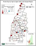
As part of the food mapping exercise the Upper Vallely Lake Sunapee Regional Planning Commission (UVLSRPC) worked with Vital Communities to identify farm stand and farmer's market locations. What we have learned so far is that there is significantly more access to food sources through farm stands than farmer's markets. Click on the map below to see the farmer days in our region. Farmer days are a measure created by the Center for Disease Control (CDC) to determine the access that the public has to the food sources.
Funders:
- US Department of Housing and Urban Development, Community Challenge Planning Grant