

Quick Links
Regional Corridor Transportation Plan
Upper Valley Strong COVID-19 Regional Info/Assistance
UVLSRPC Household Hazardous Waste Website
UVLSRPC Waste Management Website


Follow Us on Social Media!
Project Resources
Related Documents
- Orford Natural Resources Inventory Report
(PDF, 759 KB) - Orford Natural Resources Inventory Report Appendices
(PDF, 575 KB) - Natural Resources Maps, Orford
(PDF, 3.8 MB) - Interactive Map of the Orford Natural Resources Inventory
(PDF, 3.3 MB) - How to Use Digital Maps and Data from the Natural Resources Inventory
(PDF, 393 KB)
Related Websites
Related Photographs
UVLSRPC Projects
Project Administrator:
Rachel Ruppel
Project Title:
Orford Natural Resources Inventory
Related Services:
Project Summary:
The Upper Valley Lake Sunapee Regional Planning Commission(UVLSRPC) worked with the Orford Conservation Commission to develop a Natural Resources Inventory.
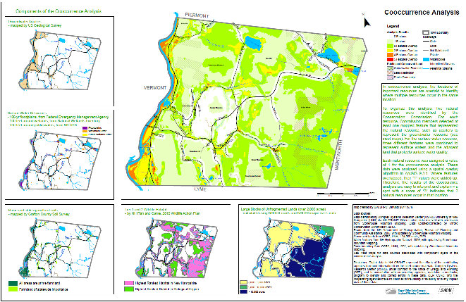
The Natural Resources Inventory of Orford, NH, identifies and describes important resources within the Town through the creation of natural resources maps based on state data, local records and field checks, analysis of natural resource overlap, and development of recommendations for improved management and protection of important natural resources. A written report was created to document the results of mapping the natural resources, analyzing the overlap or co-occurrence of natural resources, and considering recommendations for resource protection.
A number of natural resources maps were developed for this project, and UVLSRPC led a training session of how to use the digital maps and data.
Additional Information
By state law, RSA 36-A, Conservation Commissions are tasked with the responsibiliy to "keep an index of all open space and natural, aesthetic or ecological areas" and "of all marshlands, swamps and all other wet lands." This index is typically organized into a report known as a Natural Resource Inventory.
Funders:
- Town of Orford